
Where to Find Existing Property Surveys Without Ordering a New One


Where to Find Existing Property Surveys Without Ordering a New One
Understanding Property Surveys and Legal Boundary Records
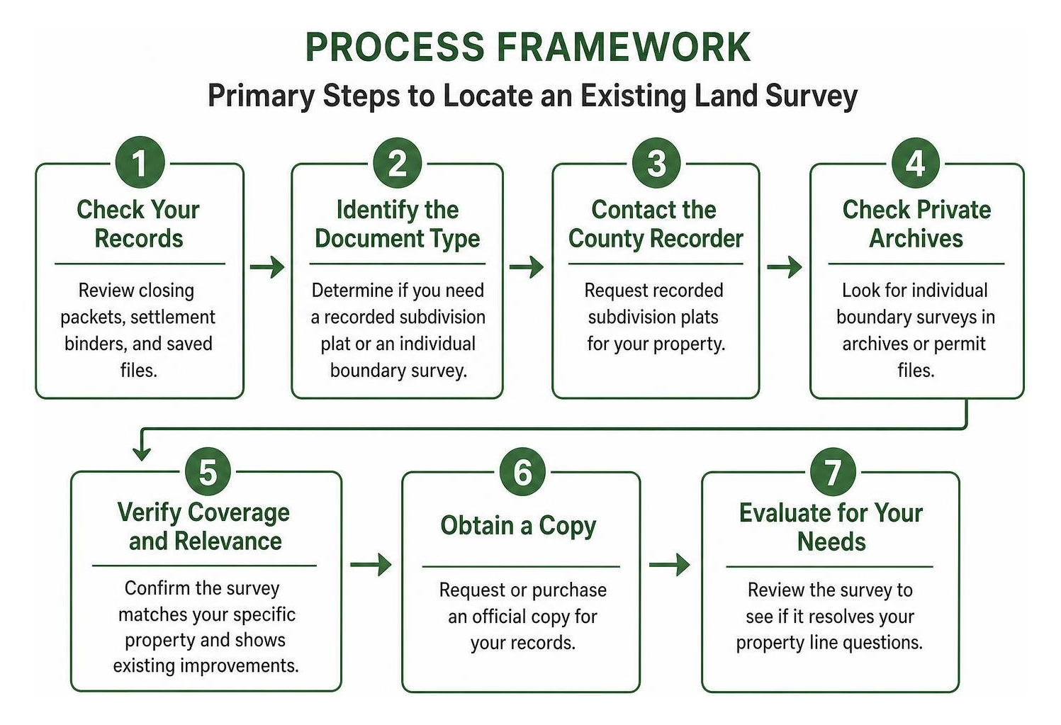
To find an existing property survey without ordering a costly new one, start by checking your closing or settlement packet, contacting your title insurance company or mortgage lender, searching past permit archives at your local municipal building department, or contacting the prior surveyor identified on your lot’s corner pins.
A property survey is a legally binding document prepared by a licensed professional land surveyor. It precisely describes, maps, and locates property ownership boundaries, corners, acreage, physical structures, and visible or recorded encumbrances. While casual sketches or tax assessor maps show general outlines, a true survey is a precision instrument backed by field measurements and historical title research.
When you review a comprehensive survey, you will find several vital elements:
- Exact Metes-and-Bounds Descriptions: Detailed angular measurements, bearings, and distances establishing boundary lines.
- Physical Boundary Monuments: Identified iron pins, concrete monuments, or drill holes marking property corners.
- Easements and Rights-of-Way: Legally defined access paths for municipal sewer lines, power grids, shared driveways, and underground utilities.
- Improvement Locations: Exact placement of primary residences, commercial structures, detached garages, sheds, driveways, retaining walls, and fences.
- Zoning Setbacks and Encroachments: Structural overlaps that cross boundary lines or violate mandatory municipal setback distances.
Commercial real estate transactions rely on strict nationwide standards. Under the 2026 ALTA/NSPS standards, an ALTA/NSPS Land Title Survey must achieve a maximum allowable Relative Positional Precision of 2 centimeters (0.07 feet) plus 50 parts per million at a 95 percent confidence level. Furthermore, field surveyors are required to identify potential structural encroachments within 5 feet of property lines and overhead utility connections within 10 feet.
Subdivision Plats vs. Individual Boundary Surveys
A common point of confusion for property owners in Pennsylvania and New Jersey is the difference between a recorded subdivision plat and an individual boundary survey.
If your deed references “Lot 14 of Block B in the Green Meadows Subdivision,” the county recorder maintains that master plat. However, that plat will not show where your specific fence or driveway sits relative to your neighbor’s property line.
Where to Get Property Survey Records: Top Sources for Existing Documents

Before paying for field crews and total station setups, explore these proven avenues to retrieve an existing record.
Checking Closing Packets: Where to Get Property Survey Copies at Home
Your personal purchase files are the fastest and most cost-effective place to look. When you purchased your residential or commercial property, your settlement package likely included survey work if required by your lender or title insurer.
- Locate your settlement binder: Review the physical or digital files provided by your closing attorney or settlement agency.
- Inspect the title insurance policy: Look through the schedules attached to your title policy. Surveys are often included as attached exhibits or referenced in the legal description.
- Review the mortgage loan package: Lenders frequently require a mortgage inspection or survey review prior to funding. Check the loan appraisal and underwriting attachments.
Contacting Local Municipalities: Where to Get Property Survey Maps on Record
Local government offices maintain property-related records, though their availability depends on past construction on the parcel.
- County Recorder of Deeds / Register of Deeds: While county offices do not typically archive private boundary surveys, they maintain recorded subdivision plats, right-of-way dedications, and historical lot splits. Property owners can consult resources like the Pennsylvania state land records overview to research historical land patents, warrants, and tract boundaries.
- Local Building and Planning Departments: If you or a prior owner pulled permits for a home addition, swimming pool, detached garage, or perimeter fence, the municipality often required a certified property survey as part of the permit application. Municipal development centers in cities like Philadelphia or suburban townships across Montgomery County, Bucks County, and South Jersey retain archived building permit jackets that contain copies of these past surveys.
- Tax Assessor GIS Portals: Most county assessment offices maintain online Geographic Information System (GIS) mapping platforms. While GIS maps are designed for tax assessment rather than legal boundary settlement, they provide property identification numbers (PIN/APN) and parcel dimensions that assist in tracking recorded documents.
Retrieving Records from Title Companies, Lenders, and Prior Surveyors
When municipal searches fail, private transaction participants often hold digital archives:
- The Title Agency: Contact the title insurance agency that issued your closing policy. Title companies maintain document archives for decades and can pull the closing survey from their digital file.
- The Mortgage Holder: Contact your original mortgage lender’s customer service or document retrieval department to request copies of underwriting documents.
- The Prior Land Surveyor: Walk your property lines to locate iron pins, pipes, or drill holes at corner points. The top of the pin often features a plastic or aluminum cap stamped with the surveyor’s name or state license number (e.g., a PLS license number). Searching that license number through state licensing registries allows you to contact the surveying firm directly. Many firms provide copies of historical survey plats from their internal archives for a minor retrieval fee, or offer a low-cost recertification.
When an Existing Survey Fails: Hiring a Professional Surveyor

While finding an existing survey saves money, relying on outdated or incomplete documentation can lead to severe legal and financial risks.
| Evaluation Factor | Existing Archived Survey | Commissioning a New Field Survey |
|---|---|---|
| Typical Cost | $0 to $100 (retrieval fees) | $1,200 to $5,500+ (depending on size and complexity) |
| Turnaround Time | Immediate to 5 business days | 1 to 3 weeks |
| Legal Standing | Valid if no alterations occurred | Legally binding under current conditions |
| Physical Monuments | Pins may be buried, lost, or removed | Fresh pins staked and visibly flagged on-site |
| Encroachment Detection | Shows historical condition only | Maps all recent improvements, fences, and drives |
| Permit Acceptance | May be rejected if older than 5–10 years | Fully accepted by local building code officials |
You should commission a new boundary survey from a licensed Professional Land Surveyor (PLS) when:
- Physical Alterations Have Occurred: You or your neighbor added driveways, retaining walls, sheds, or fences that were not present when the original survey was drafted.
- Corner Pins Are Missing: Physical iron monuments have been removed, paved over, or displaced during utility excavation or grading work.
- You Are Undertaking Permitted Construction: Most municipal building departments require a current survey (often completed within the last 1 to 5 years) to verify zoning setbacks before approving structural permits.
- An Active Boundary Dispute Arises: If a neighbor claims your fence encroaches on their property, an outdated sketch cannot substitute for an active field survey backed by corner markers. Under Pennsylvania and New Jersey real estate laws, unresolved encroachments can lead to costly legal disputes or claims of adverse possession if open and hostile use continues over the statutory period.
Types of Modern Surveys and Cost Considerations
When commissioning new fieldwork, select the specific survey format that matches your legal and operational goals:
- Boundary Survey ($1,200 – $5,500): The standard residential survey. The surveyor researches deed records, measures property lines, sets physical corner pins, and delivers a certified plat showing all boundary lines and existing structures.
- Topographic Survey ($2,000 – $6,500): Maps boundary lines alongside elevation contours, trees, grading changes, and drainage paths. This is essential for civil engineers and architects designing major additions, new homes, or commercial drainage facilities.
- ALTA/NSPS Land Title Survey ($2,500 – $10,000+): A specialized, comprehensive survey conforming to national title standards. It is standard for commercial acquisitions, retail centers, and industrial parcels where title insurers require the complete removal of survey exceptions.
- Mortgage Location Survey ($1,000 – $3,800): A simplified document showing the home’s position on the lot relative to deed lines for underwriting purposes. It does not establish permanent physical corner pins on the ground.
Frequently Asked Questions About Finding Property Surveys
Do local city governments keep copies of private property surveys?
No, municipal public works departments and county clerk offices generally do not maintain ongoing repositories of private property surveys. Municipal surveying divisions focus primarily on public rights-of-way, capital improvements, and municipal monumentation networks.
However, local building inspection departments may have a copy of a private survey saved inside historical building permit archives if a prior owner submitted one to obtain a construction permit.
Can I legally rely on a mortgage location certificate to build a fence?
No. A mortgage location certificate or inspection is designed solely for lender underwriting to confirm that a structure sits generally within parcel boundaries. It does not establish exact boundary lines with legal precision, nor does the surveyor physically locate or drive boundary pins into the corners of your lot. Using a mortgage location map to install a fence or permanent structure can result in unintentional encroachments and property disputes.
How long is an existing property survey valid?
A property survey does not have a formal statutory expiration date. As long as no boundary lines have changed, no land has been subdivided, and no new structural additions, driveways, or fences have been built on either parcel, the survey remains historically accurate.
However, title insurance companies, mortgage lenders, and municipal building code offices frequently require a survey certified within the past 6 months to 5 years to ensure recent unrecorded improvements do not violate boundary setbacks.
Conclusion
Locating an existing land survey can save thousands of dollars in preliminary construction and closing expenses. By checking your personal closing binder, consulting local municipal permit jackets, and reaching out to the original title company or surveying firm, you can often retrieve certified boundary records quickly.
However, when property lines are contested, physical pins are missing, or major commercial developments are underway, clear boundary documentation is critical. If boundary uncertainties develop into neighbor conflicts, easement disputes, or title defects, securing knowledgeable commercial litigation and property dispute counsel ensures your legal rights and property values remain protected. Alan L. Frank Law Associates, P.C. represents property owners, businesses, and developers across Pennsylvania and New Jersey in navigating complex real estate matters and resolving high-stakes land disputes.